Wednesday 19 February 2014

Famous Rivers in Pakistan


Pakistan’s river system consists of more than 60 small and large rivers. Indus River, with an overall length of around 3200 KM and total estimated annual flow of 207 billion cubic meters, is Pakistan’s longest and largest river. This is a list of some rivers wholly or partly in Pakistan.
Indus River

The Indus River is a major river in Asia which flows through Pakistan. It also has courses through western Tibet and Northern India. Originating in the Tibetan Plateau in the vicinity of Lake Mansarovar, the river runs a course through the Ladakh region of Jammu and Kashmir, towards Gilgit and Baltistan and then flows in a southerly direction along the entire length of Pakistan to merge into the Arabian Sea near the port city of Karachi in Sindh. The total length of the river is 3,180 km (1,980 mi). It is Pakistan's longest river.

Beas River

The Beas River is a river in the northern part of India. The river rises in the Himalayas in central Himachal Pradesh, India, and flows for some 470 km (290 miles) to the Sutlej River in the Indian state of Punjab. Its total length is 470 km (290 miles), and its drainage basin is 20,303 square kilometres (7,839 sq mi) large.The Sutlej continues into Pakistani Punjab and joins the Chenab River at Uch near Bahawalpur to form the Panjnad River; the latter in turn joins the Indus River at Mithankot. The waters of the Beas and Sutlej rivers are allocated to India under the Indus Waters Treaty between India and Pakistan.

Jhelum River

Jehlam River or Jhelum River is a river that flows in India and Pakistan. It is the largest and most western of the five rivers of Punjab, and passes through Jhelum District. It is a tributary of the Chenab River and has a total length of about 450 miles (725 kilometers).

Hub River

Hub River is located in Lasbela, Balochistan, Pakistan. Hub river starts from the Pab Range in the south eastern balochistan and continues with the border of Sindh it reaches Hub and then falls into the Arabian Sea.

Astore River
Astor River is a tributary of the Indus River and one of the rivers draining the Deosai Plateau, running through Astore Valley. The river originates from western slopes of Burzil Pass. Astor river joins Gilgit River at coordinates 34°00′N 74°41′E.

Bara River

Bara River is a river in Khyber Agency and Khyber Pakhtunkhwa, Pakistan. The Bara River originates in the Tirah Valley of Bara Tehsil, Khyber Agency. It joins the Kabul River Canal which originates from the Warsak Dam, and enters Peshawar. Then it flows in the North-easterly direction to the Nowshera District, eventually joining the Kabul River near Camp Koruna, Akbarpura. Due to its higher elevation, very limited areas flow through gravity into Bara river.

Tawi River

Tawi is a river that flows through the city of Jammu. Tawi river is also considered sacred and holy, as is generally the case with most rivers in India.Tawi river originates from the lapse of Kali Kundi glacier and adjoining area southwest of Bhadarwah in Doda District. Its catchment is delineated by latitude 32°35'-33°5'N and longitude 74°35'-75°45'E. The catchment area of the river up to Indian border (Jammu) is 2168 km² and falls in the districts of Jammu, Udhampur and a small part of Doda. Elevation in the catchment varies between 400 and 4000 m.

River Jindi
The River Jindi, also known as Kot and Manzari Baba, begins in the hills of Malakand Agency, in the northern district of Charsadda, in Khyber-Pakhtunkhwa, Pakistan. During the early months of each year, the River Jindi has a very limited water supply, but the summer months bring with them much needed rain to water the area. As the river proceeds downstream, the local people use dams, similar to the Warsak Dam on the Kabul River, to take out water for irrigation; therefore, the amount of water flowing downstream decreases.

Rupal River

The Rupal River is an east-west glacial stream rising from the meltwater of the Rupal Glacier in northern Pakistan. The stream flows through the Rupal Valley, south of Nanga Parbat, before turning northeast to the village of Tarashing. The Rupal drains into the Astore River, which eventually reaches the Indus near Jaglot.

Shingo River

The Shingo River is a tributary of the Suru River, and flows through the Ladakh region. The Shingo river enters India from Pakistan-administered Kashmir and meets the Dras River, coming from Dras. 5km from Kargil the merged river meets the Suru River and again re-enters Pakistani territory. The Shingo river is clearer than other rivers in Ladakh because it is formed from melting ice.

Thursday 13 February 2014

Pakistan Lowari: Frozen travellers trapped by an unfinished tunnel

Water dripping from the top of the crumbling, cave-like opening of an unfinished tunnel in northern Pakistan forms into icicles, accentuating the bite of a freezing January morning.

About a kilometre down the valley behind, a large huddle of passenger vans, trucks and cars waits for the tunnel to open. They have been here for many endless hours.

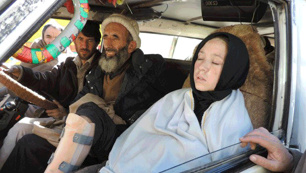
In one rented vehicle is the coffin and body of an old woman on way to her own funeral, but she is running late.

On the other side of the mountain, in her home village, people have already gathered for the burial.


Anxiety is writ large on the face of her son, Wali Ahmad, a soldier in the Pakistani army and a resident of Chitral district, located on the far side of the 8.6km (5.2-mile) Lowari tunnel.

"My mother died in Peshawar. Now we have to take her home for burial. We don't know if they will open the tunnel in time for us to make it there in daylight," he says.

It's at least three hours' drive to his village of Golen from where he's standing. It's already approaching midday, and the towering mountains of the Hindu Kush range shut off the winter sunlight from most of Chitral's 34 branch valleys after 4pm.

At a little over 7,000 feet (2,500m) above sea level, the tunnel is the only exit route in winter for the 500,000 population of Chitral.

Dozens of loaded trucks are parked every few kilometres along the rocky, broken mountain road that winds up from the town of Dir to the tunnel.

Some drivers have lit gas cylinders beneath the engines to keep them warm and prevent the pipes from bursting due to freezing temperatures.

Mohammad Qasim Khan, a resident of Drosh area in Chitral, is the head of another party waiting for the tunnel to open.

"My daughter's just been operated for appendicitis, and my cousin got a rod fixed in his left leg which suffered a fracture," he says.

"They can't stand the cold and the wait, but we are told the tunnel is closed. We drove some eight hours from a hospital in Peshawar, and now we've been stuck in this wilderness for more than six hours. There's no food or heating here, and there are no toilets."

It is the same story on the Chitral side of the tunnel - residents taking sick relatives to hospitals in Peshawar, students and job seekers trying to make it to their appointed interviews, and workers with jobs in the Gulf fretting over whether they'll be able to catch their flights from Peshawar and Islamabad.

All these people are caught in a gridlock that started when the government suddenly decided to reschedule work on the tunnel ahead of this winter.


The fortunes of the people of Chitral have fluctuated with the fortunes of the Lowari tunnel project.

In summers, a road built by the British over the 10,230ft (3,140m) Lowari Pass links them to Khyber Pakhtunkhwa province, of which Chitral is a part. But the pass closes in mid-December due to snow.

Two other passes - one connecting Chitral to the Afghan province of Badakhshan, and the other linking it to Pakistan's north-eastern Gilgit-Baltistan region - are more than 12,000 feet high and also remain snowbound in winters.

The region's only natural all-weather route passes through its south-western town of Arandu into Afghanistan, and follows a southward route via the Afghan provinces of Kunar and Ningarhar into Pakistan's Peshawar valley.

But that is no longer an option.

"The Arandu route closed when a Pakistani military operation in the Swat region in 2009 pushed Islamist militants into the Kunar region," says Shahzada Iftikharuddin, Chitral's representative in Pakistan's national parliament.

"This happened when the Americans wound up their bases in the Kunar region, making it possible for these militants to set up sanctuaries there. A number of Chitrali travellers were held and beheaded by them in 2010."

The tunnel was commissioned in late 2005, and by 2008 the construction contractor, Sambu JV of South Korea, had dug the 8.6km tunnel all the way through. But funding for the project stopped when a new government took over.

Over the next few years, this unfinished tunnel remained open for winter traffic.

In 2011, when some funds became available and work commenced, public use of the tunnel was restricted to three alternate days in a week. This catered to the needs of the locals and there was no crisis.

But after the first snow in late November this year, the commuters were shocked to discover that a new standard operating procedure (SOP) permitted three days of transit through the tunnel only every two weeks instead of one.

Hundreds of people were stranded in the snow. Those with money had to spend weeks in Dir town's hotel rooms. Others slept in their vehicles or turned back.


In Chitral, food supplies became scarce, sparking protests that finally forced the authorities to revise the SOP and open the tunnel twice a week - on Saturdays and Sundays - for six hours a day.

The authorities defend the new arrangement as the only viable balance between human suffering and project completion.

"The project cost has escalated from 5bn rupees to 18bn, and we have to pay penalties to the contractor for idle hours," says Hameed Hussain, the project director of Lowari tunnel.

Besides, six hours of public traffic pushes carbon levels inside the tunnel beyond human tolerance.

"We need an extra four to five hours to ventilate the tunnel before the workers can get to work safely," he says.

At the moment, there is no proper lighting in the tunnel, no exhaust system and no emergency services.

Most of the tunnel is still without the shotcrete lining, retaining walls or a metalled road. Water seepage from the ceiling and walls forms into puddles on the floor.

In addition, the widening process leaves the tunnel floor strewn with debris, causing traffic jams inside the tunnel and endangering those travelling in open vehicles.

Mr Hussain says he recovered four persons from a truck that had broken down inside the tunnel last week. All of them had fainted.

But bound by towering mountains on all sides, the people of Chitral are just too desperate not to take a chance with this drive through hell.

And those who can't make it, rue it.

Naila Shahid is one of them.

A graduate in environmental sciences, she had to miss an interview for an assistant professor's job at a university in Dir district because that would mean living in a hotel room for a whole week - a social and financial impropriety.

"I was on top of the merit list. I received a call to appear for the interview. I knew I couldn't make it because the tunnel would have closed by the time I was finished and would next open only on the following Saturday," she says.

"There is no male member of the family available to accompany me for a week in a strange land. I cried last night. This job would have helped me enroll for a doctorate."

The new deadline for the tunnel's completion is 2017. Until then, every time the snows block the passes, many funerals are likely to be missed, many careers suffer setbacks and many tears are shed in Chitral. 

Wednesday 12 February 2014

Important Information about Pakistan

Important Informations About Pakistan

We know a lot more about other countries but we don't know most of the important information about our beloved country Pakistan. Today in this article we will provide you the some important information about Pakistan. May be most of them you know before but some of them will be new and interesting for you.

The name "Pakistan" was recommend by Choudhary Rehamt Ali in 1933.
On 03-June-1947, It was announced the creation of Pakistan.
Pakistan joined the United Nation on 30-September-1947


Pakistan launches it's first coin on 03-June-1948
Pakistan launches it's first post ticket on 09-July-1948
Islamabad becomes the capital of Pakistan in 1960


Pakistan
Pakistan is the best country in the world and it was appeared on the map of the world on 14th August 1947 and it was the 27th night of the Ramadan Karim too. It has four provinces Sindh, Punjab, Balochistan and KPK, Every province is famous in the world and Karachi is the biggest city of the Pakistan and the City of light is the nick name of Karachi city. Lahore is the heart of Pakistan and it has lots of natural beasutifull lands which are most famous in the world for their buties and most of the peoples says them the world's Paradise.

We are in this blog will post the beautiful images and the features of Pakistan because we know that Pakistan has many features and beauty and we want your help in this work. Our aim is to develop our country.